


NORWAY’S
National Gravel Routes
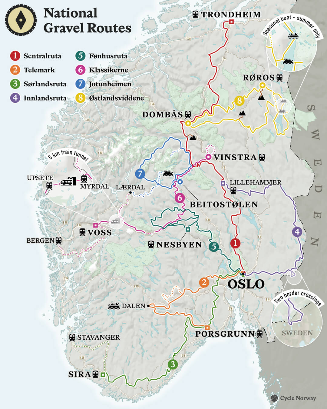
World’s First National Gravel Network
National Gravel Routes is a hand-picked, field-tested network of Norway’s best long-distance gravel routes, developed by Cycle Norway to keep riders deep in landscapes few ever see. Linking quiet gravel roads, remote valleys, forests, and high mountain terrain, the routes form the world’s first national gravel route network, showcasing Norway as one of the strongest gravel riding environments on the planet.
How do I download the GPX Files? Scroll down to the main RWGPS map and click on the line you want to ride.
Click ‘View Route‘ → Click ‘More‘ → Click ‘Export as File‘
You will need to set up a free RWGPS account to download the GPX File
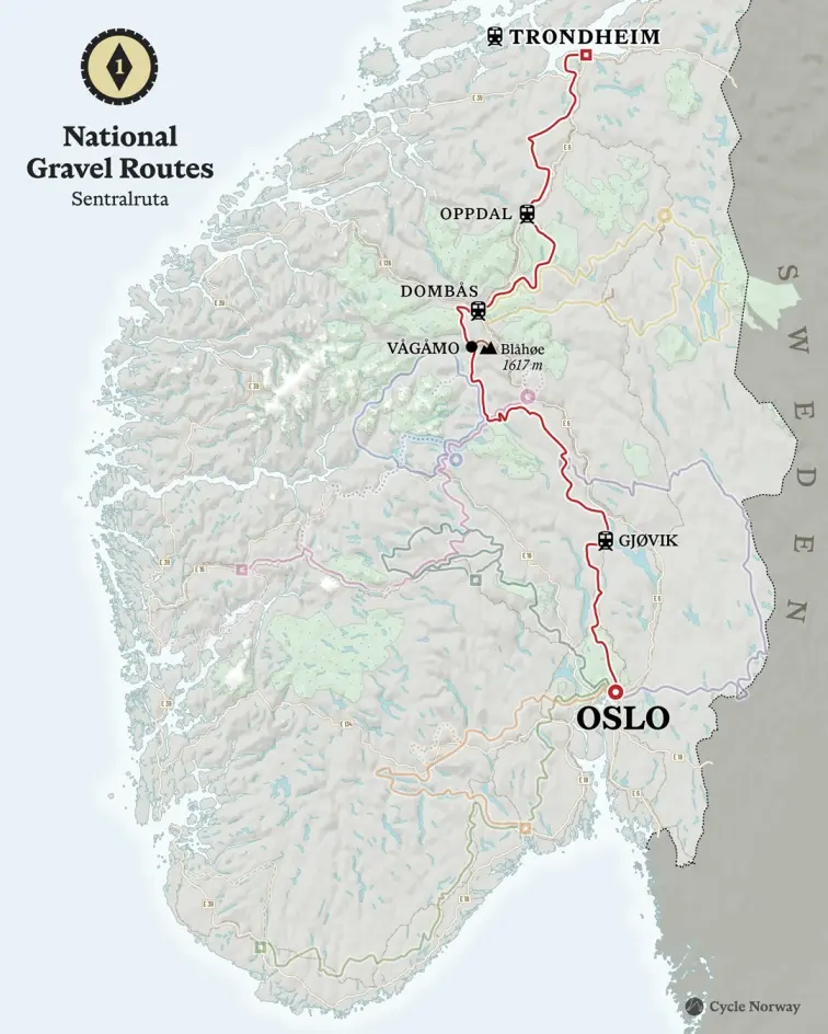
National Gravel Routes 1: Sentralruta
The Central Route (Oslo–Trondheim)
The backbone of the network, linking Oslo and Trondheim through Norway’s inland landscapes. A long inland traverse across forests, valleys, and mountain regions, following historic travel corridors between south and north.
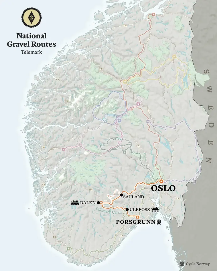
National Gravel Routes 2: Telemark
Telemark
A historic inland route through Telemark’s forested hills, lakes, and valleys. The route follows sections of the Telemark Canal and some of Norway’s best-preserved gravel and historic roads, reflecting a strong cultural identity shaped by traditional inland travel and outdoor life.
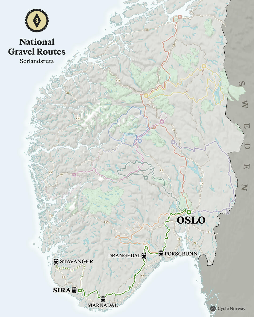
National Gravel Routes 3: Sørlandsruta
The Southern Divide
A long inland crossing of southern Norway, running from Oslo towards the Stavanger region in the south-west. The route follows watershed divides, remote valleys, and lesser-known backroads, linking multiple landscapes and several counties.
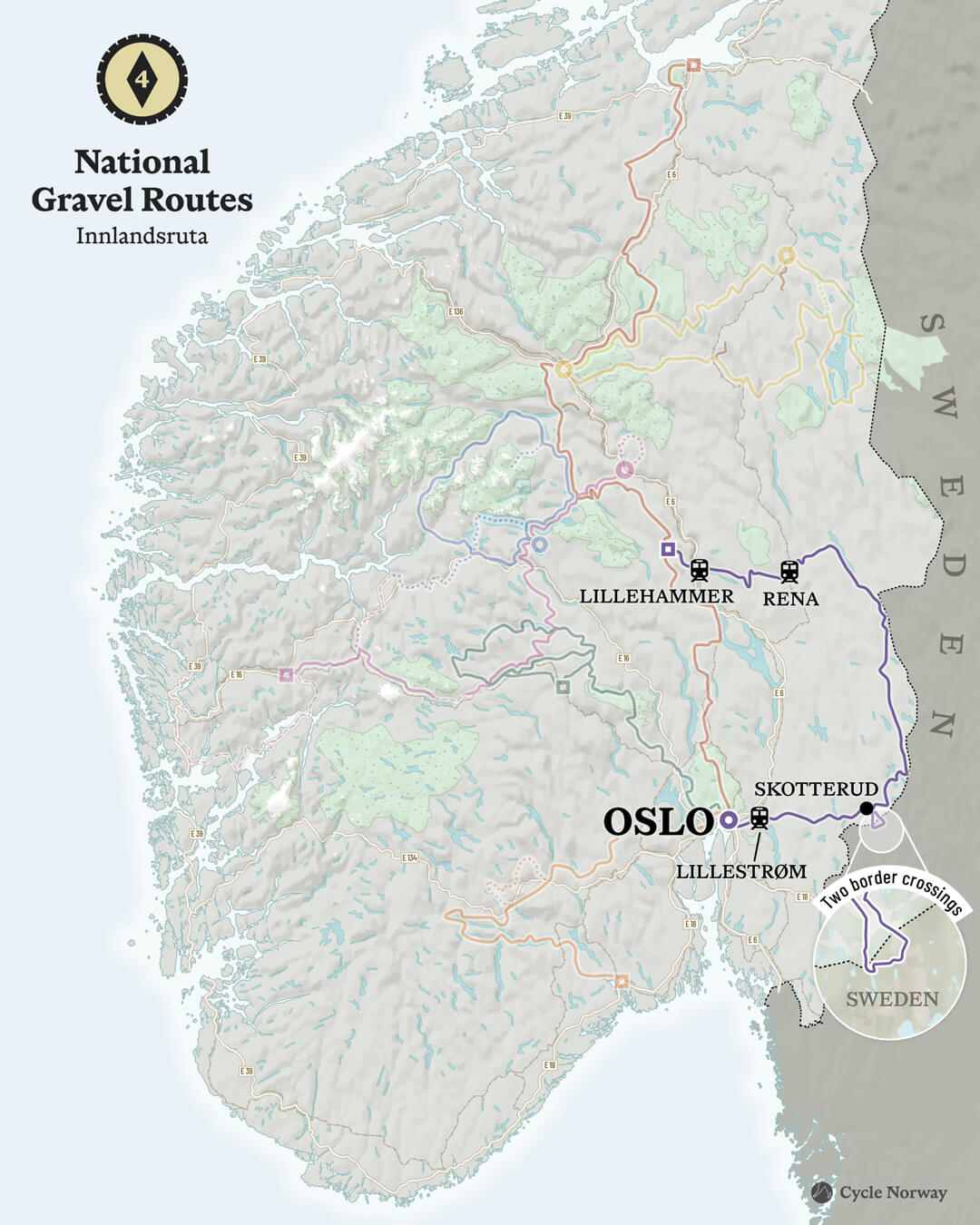
National Gravel Routes 4: Innlandsruta
The Inland Trail
A remote route through Norway’s interior backcountry, following gravel roads and tracks across forests, uplands, and sparsely populated areas. Emphasises remoteness, self-reliance, and access to landscapes beyond the main tourist corridors.
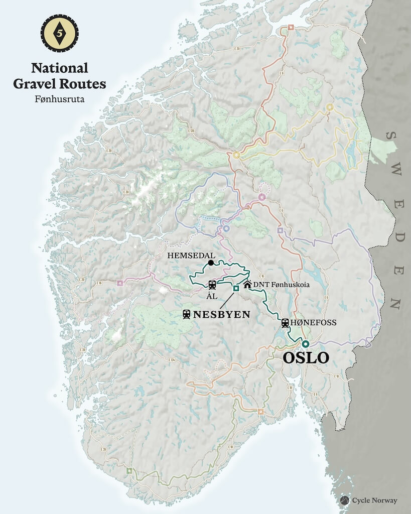
National Gravel Routes 5: Fønhusruta
Fønhus Route
Tracing the transition from preserved backcountry landscapes to Norway’s hydropower heartland, this route runs from the capital region into the Hallingdal mountains. It passes DNT cabins, conservation areas, and power infrastructure, telling the story of nature, people, and energy.
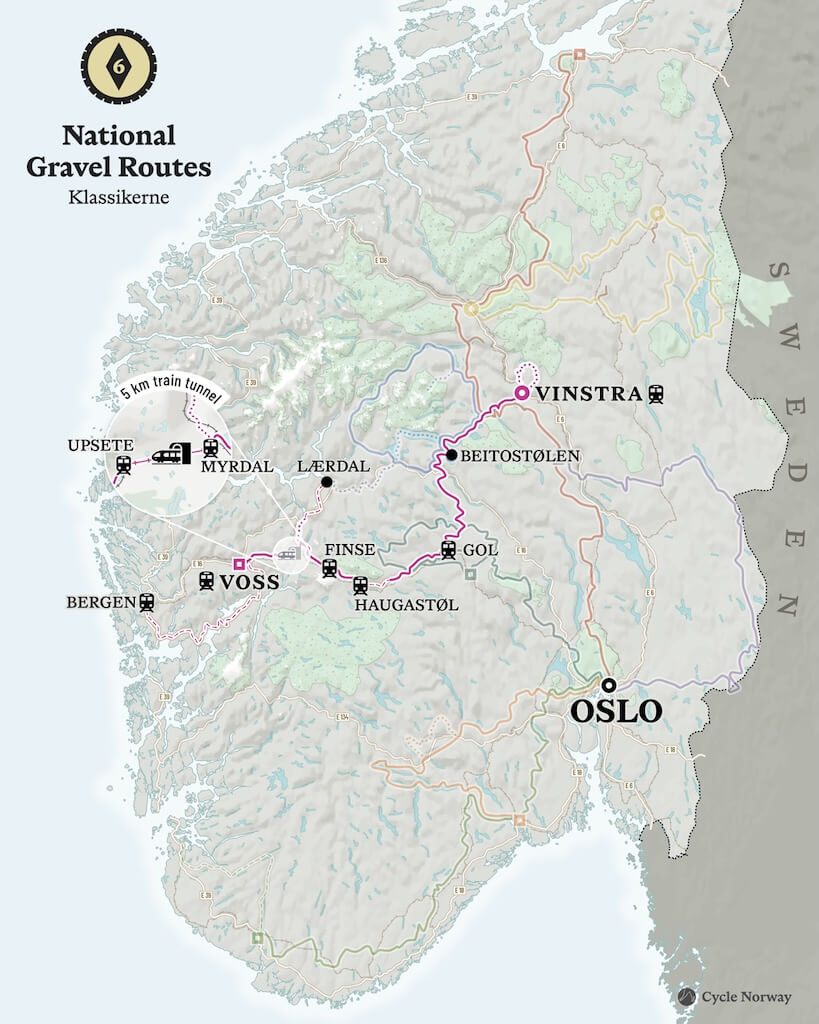
National Gravel Routes 6: Klassikerne
The Norwegian Classics
A collection of Norway’s most iconic historic gravel roads, including Rallarvegen and Mjølkevegen. These routes follow traditional travel corridors shaped by trade, industry, and early infrastructure, and remain cornerstones of Norwegian cycling culture.
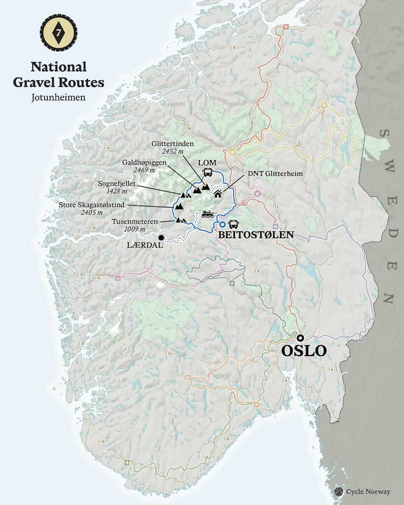
National Gravel Routes 7: Jotunheimen
Jotunheimen
The land of the giants is your destination. A high-mountain route through the spectacular Jotunheimen region, including roads such as the world-famous Tusenmeteren and crossing some of Norway’s most dramatic alpine terrain. High passes, open plateaus, and rugged landscapes define this demanding yet rewarding journey.
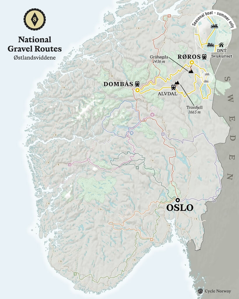
National Gravel Routes 8: Østlandsviddene
The Eastern Highlands
A high inland route across eastern Norway, linking areas such as Røros, Femund, Rondane, and Dovre. Wide plateaus, open landscapes, and a strong sense of scale define this remote and elevated journey across a forgotten part of the country.
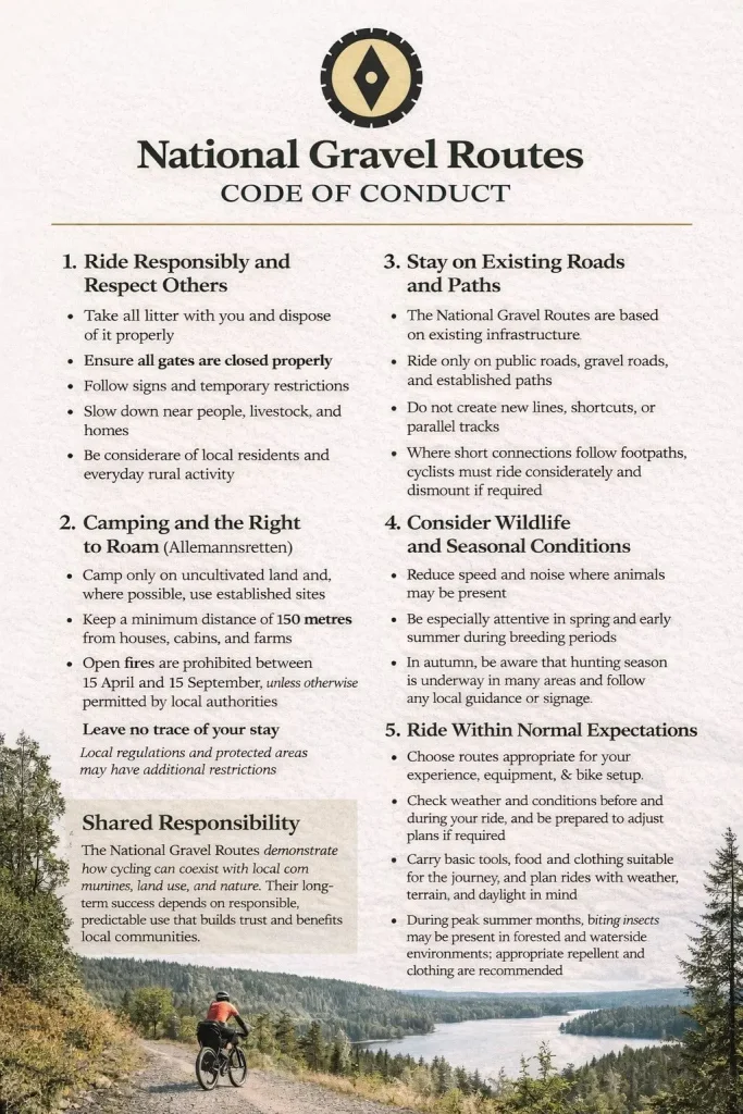
Keep in mind
All cycling routes published on CYCLENORWAY.com are intended as planning resources and sources of inspiration to be used alongside your own research and judgement. Routes are created using careful research, but every cyclist has different abilities, expectations, and risk tolerance. Some challenging gravel routes may include hike-a-bike sections, muddy or wet hiking paths, technical terrain, steep climbs, descents, or remote areas that may not be suitable for everyone. Route mapping software, and conditions can also change or contain inaccuracies. Cycling in Norway is generally very safe. Nevertheless, if you choose to ride these routes, you do so at your own risk. If you are unsure about a certain route leave a comment below and we’ll advise you.

Route Criteria
National Gravel Routes must meet the following criteria:
- A minimum of 50% gravel or unpaved surface, on roads and tracks with full public access
- Minimum total length of 350 km, ensuring multi-day, long-distance relevance
- Interconnected routes, allowing riders to combine, shorten, or extend journeys as needed
- Alignment chosen to avoid busy roads, prioritising quiet gravel, forestry roads, and low-traffic connections
- Varied landscapes and terrain, such as forests, valleys, uplands, plateaus, and mountain regions
- Rideable by recreational cyclists, with difficulty varying by terrain rather than technical extremes
- Reliable public transport access at both start and end points
- Regular access to food and accommodation, enabling flexible stage planning
- Grounded in landscape, history, and culture, following established travel corridors rather than arbitrary lines on a map
- Field-tested and periodically reviewed by Cycle Norway, with updates reflecting real-world riding conditions
FAQ
For detailed information, please refer to each individual page. Here’s a quick overview of the most frequently asked questions.
In general, no. The routes are created by Cycle Norway, which is an independent private company. They are not part of any official, state-run system.
Some sections do follow parts of Norway’s national cycle route network, and in places you may encounter official cycling signage. Routes such as Mjølkevegen and Rallarvegen, which form part of National Gravel Routes 6, also have their own local signage in certain areas.
Overall, you should rely on a cycling computer or a fully charged phone with the GPX file downloaded. On several sections, it is easy to lose your way without proper navigation.
Start and end points are connected to Norway’s main rail lines, including Oslo–Trondheim, Bergen–Oslo, Stavanger–Oslo, and Røros–Oslo. Towns along the routes are served by regional bus networks, with bicycle carriage typically permitted subject to space. All public transport planning and booking is handled through entur.no.
These routes pass through historic and well-known regions of Norway, but services can be limited in places. Accommodation varies by section and may include campsites, mountain cabins, or hotels where available; in some remote areas, wild camping may be the most practical option. Villages and towns along the routes provide opportunities to resupply, though food gaps of up to 75 km can occur. Fresh water is available in many areas from mountain and forest streams.
Lowland forest routes are best ridden in May and June, when winter snow has cleared and mosquito levels are typically low. September also offers good conditions, with cooler temperatures & minimal insects. In some areas, April can provide early-season riding where snow is not an issue, though this varies by region and year.
High mountain routes are more dependent on winter snowfall and spring temperatures. Snow may persist until mid-June, and in some years into early or mid-July. Conditions vary significantly from year to year.
Forest routes can often be ridden into October, while high mountain roads usually close during October as winter conditions return. Each route overview page provides more precise, route-specific information.
In general, these routes are not suitable for children. They require a degree of cycling experience and involve significantly more elevation gain than paved roads.
That said, some individual sections, such as Rallarvegen, which is widely regarded as child-friendly, may be appropriate depending on the child, conditions, and expectations.
Careful planning and a realistic understanding of terrain, weather, and available resources are essential before attempting any part of the National Gravel Routes with children. Book a consultation call if you require further help planning a child-friendly route.
These routes were designed primarily for bikepacking, with a light setup and bikes capable of handling a wide range of terrain. A gravel bike or mountain bike is best suited, with a minimum tyre width of 40 mm recommended for comfort, traction, and control.
Gearing recommendations:
- Minimum: 36T rear — suitable for experienced riders on a light setup
- Recommended: 42–46T rear for improved comfort and control
- Ideal for loaded bikes: 46T+ rear or a true sub-compact 2× drivetrain
Many sections follow well-established, well-maintained hard-packed gravel roads, which touring bikes and heavier pannier setups can manage. Routes that are well maintained and supported by accommodation with charging facilities, such as Mjølkevegen and Rallarvegen, will be suitable for E-bikes. However, other sections include long, remote stretches and more demanding terrain, with short hike-a-bike segments, typically ranging from 500 m to 3 km, where pushing or carrying the bike is required. Riders should also expect low stream crossings, narrow singletrack through overgrown forest (sometimes wet and muddy), and very rough, uneven roads that are unmaintained and affected by weather and flooding. For these sections, a gravel or MTB is strongly recommended. Each route overview provides detailed information on what to expect. Riders should use this to make their own judgement about whether the route is suitable for their fitness level and bike setup.

Mobile phone reception can be nonexistent in many sections of these routes. Routes should be downloaded for offline use before setting out. Ride with GPS offers offline navigation as part of its subscription service.
In general, a satellite emergency device is not required and something most Norwegians would not carry. However, for those travelling alone who are uncomfortable in remote areas, carrying one may provide added peace of mind.
The National Gravel Routes are a relatively new concept and are not affiliated with any bike rental companies or local tourism organisations. Bike rental options in Norway are limited, and providers change frequently, making it difficult to keep an up-to-date recommendation list.
Most riders start their trip in Oslo, where a small number of rental providers may be able to accommodate gravel or touring setups. For current options, see our Bike Rental page for an overview of known providers and practical considerations.
Lowland areas through forest and open farmland generally experience comfortable temperatures during the summer months. In spring and autumn, gloves and a solid layering system may be required.
In high mountain regions above 1,000 metres, average temperatures are often in single digits, even in summer. On unsettled days, rain and strong winds should be expected in exposed areas.
Check our gear list for clothing and camping recommendations.


