Trondheim - Bodø

La côte atlantique (Eurovelo 1)
Le voyage vers l'Arctique vous attend sur l'une des routes de longue distance les plus populaires de Norvège. La beauté est à chaque coin de rue.

Quand

Mai - septembre

Rédigé par

Matthew Tolley

Distance

817km

Jours

5-14

Point culminant

342m

Difficulté

3/10

Non goudronné

0%

Montée totale

8553

Ferries

9

Tunnels

19

The Journey to the Arctic

Welcome to the Coastal Route, or ‘Kystriksveien’ as it’s known in Norwegian. Running from Trondheim to Bodø, this long stretch of coast has been voted one of the finest road trips on the planet. Strangely, it remains one of Norway’s least-visited regions.

The shoreline is broken into more than 12,000 islands, with sharp, unmistakable mountains rising straight out of the fjords. It’s a landscape that keeps surprising you, hour after hour.

If you like the idea of sleeping on the Arctic Circle while the midnight sun skims the horizon, you’re in the right place. If you want remote islands, quiet roads, and summit hikes, you’ll find that too. When the weather settles, this is about as close to a cycling-holiday paradise as Norway offers.

Some photos on this page are provided with permission from VisitNorway.com

Carte

A favourite among cycle tourists

This stretch of Norway is a genuine journey into the unknown. Once you roll out of Trondheim, it doesn’t take long before you feel the pull of the frontier. The towns thin out, the noise disappears, and before you know it you’re pedalling through a landscape where only scattered farms remind you that anyone lives out here at all.

The small communities you pass carry the feel of an older, simpler Norway. You’ll see people fishing lakes and rivers that look unchanged for generations. By the time you reach Brønnøysund, you may even wonder if you’re still in the same country, the character of this region is completely different from both the north and the south. I call it “the forgotten Norway you won’t forget.”

Expect ferries, at least nine of them, all free, but all running on their own timetable. You either plan them properly or accept that a couple of hours on a quiet quayside is part of the deal. There are many tunnels too, but they’re mostly calm and straightforward (although some are long)! Traffic is low, kept in check by the ferry system, and you’ll have long stretches of road entirely to yourself.

Detours are part of the magic. The UNESCO-listed island of Vega is well worth the effort, and if you’ve got the time and the legs, there’s even the chance to ride right up to the edge of a glacier arm. Details are in the maps below.


Galerie

The entire route is well signposted and fully paved, with reliable road conditions throughout. Fjords, glaciers and a broad mix of mountain peaks give you something new to look at every day. And if you camp on the Arctic Circle and watch the sun skim the horizon, you’ll understand why this stretch has become a bucket-list ride for long-distance cyclists.

Difficulty of the Route

This is one of the flattest regions to cycle in Norway. Early on, you’ll meet a few hills, with one climb topping out around 300 m. After that, the terrain settles down and becomes surprisingly gentle. Later in the trip, there’s another demanding 300 m-plus climb around a stunning fjord — tough, but worth every pedal stroke for the view from the top. Be prepared for strong winds on unsettled days, especially along the exposed coastal sections.

Although the route travels through a sparsely populated region, there are enough shops and campsites/hotels to ensure you won't have many logistical problems. The route is reasonably flat for large segments and comfortable for most levels.

Vega Island Detour

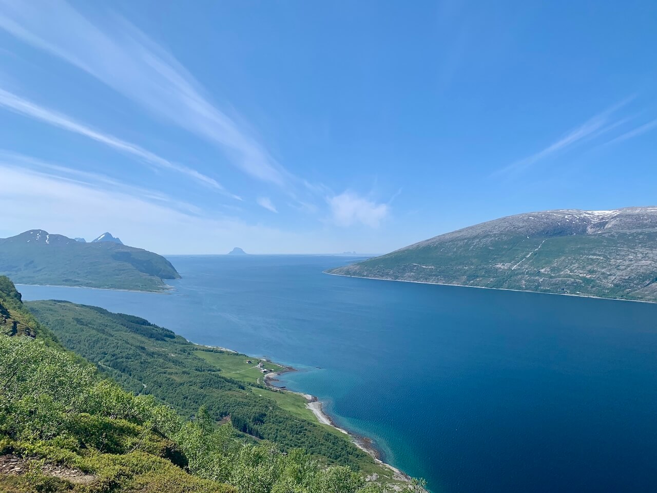
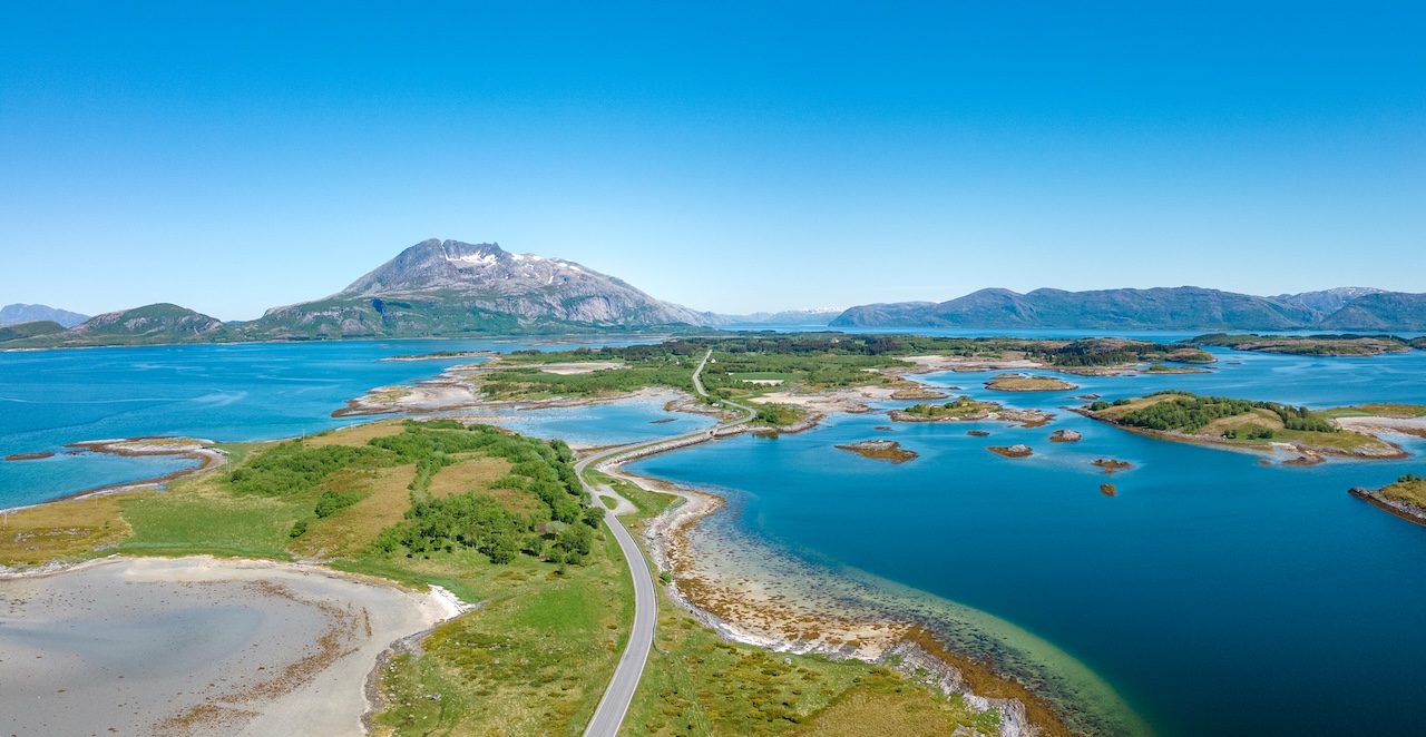
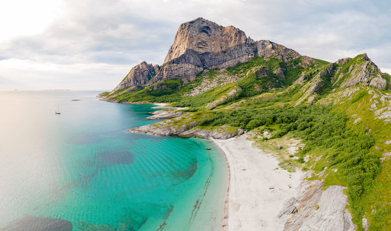
The Vega Archipelago is a world heritage site and one of the wonders of this coastline. People have been fishing in these waters for over 10,000 years, and the main island Vega has some unique rock formations that date back to 2 billion years ago. If the weather is settled it's well worth the detour to cycle.  Read more about the island ici

Glacier Cycle and Hike Detour

A short detour from the main route will take you to one of the most famous glacier arms in Norway. The Svartisen glacier has daily summer boat services to the glacier and if you like you join a group and walk up the glacier. Book in advance

Points forts

Tourist Attractions

  • Nidaros Cathedral (1300 AD) – Norway’s Gothic masterpiece. Even if you’re not into churches, the scale and stonework command respect.
  • Trondheim Fjord – A calm, wide stretch of water that sets the tone for the journey north.
  • The coastal town of Brønnøysund
    – Pretty, friendly, and a natural stopping point before the landscape begins to feel wild again.
  • Detour to Torghatten – The mountain with a hole straight through it, around 30 km south of Brønnøysund. The hole is enormous, and walking through it gives you a surreal view of the surrounding islands.
  • The Seven Sisters – A row of seven distinct peaks rising above the Helgeland coast. One of Norway’s most recognisable mountain ranges.
  • Camping on the Arctic Circle – Watching the midnight sun hover above the horizon is as close as you’ll get to time standing still.
  • Ureddplassen – Yes, it’s a toilet. But it’s also a piece of architectural design perched by the sea, with views good enough to make you linger.
  • Saltfjellet–Svartisen National Park – A vast, stark, beautiful region of mountains, plateaus and glacial valleys. This is where Norway begins to feel truly Arctic.
  • Saltstraumen – The world’s strongest tidal current. Stand by the bridge and watch the water fold, twist and boil under its own power.
  • Svartisen Glacier – A short boat ride takes you to the glacier’s edge. Most riders join a guided hike, and the blue ice is worth every step.
  • Wild reindeer encounters – Saltfjellet is reindeer country, and you often see entire herds crossing the open landscape.
  • Bodø – The gateway to the north. A fast-growing Arctic city with a rugged coastline and the feel of a place that sits on the edge of something bigger.
  • Detour to Rødøyløva – A climb worth your legs. The summit delivers one of the best panoramic views in Norway: a maze of islands, turquoise shallows and sharp peaks scattered to the horizon.

Doit savoir

  • Arriver et repartir
    Flying into either Trondheim or Bodø from Oslo is simple, and both cities are well connected by rail. The full Oslo–Trondheim–Bodø train line is a long haul — roughly 18 hours end to end — so only choose it if you genuinely enjoy long-distance train travel. A practical alternative is to start or finish in Brønnøysund, which breaks the journey nicely. The town is reachable by Hurtigruten/Havila coastal ferry from Trondheim or by domestic flights.
  • Quand partir ?
    The best season is early May to late September. May and June are usually cooler but drier, while July and August bring warmer temperatures and more rain. Early-season riders should be prepared for cold nights — a 3/4-season sleeping bag is the sensible choice if camping. The midnight sun appears from early June in the northern sections.
  • Alimentation et fournitures
    There are more village shops along this route than you might expect, but their opening hours can be short. Some close as early as 15:00 or 16:00, and Sunday trading is extremely limited. Plan ahead and carry spare food if you’re rolling into a remote village late in the day. Update – more village shops are now operating 24/7 access with a bank card reader on the door that gives you access. This will not be the case for every shop, but expect to find some along the way.
  • L'eau
    Water is rarely a problem. You’ll find taps at gas stations, supermarkets, ferry terminals and public toilets. Beyond that, streams and waterfalls run straight off the mountains — cold, clean Arctic meltwater. Fill up often and you’ll never run dry.
  • Type de vélo
    Road, gravel and touring bikes all work fine here. The roads are paved throughout, so the priority is comfort rather than tyre choice or gearing. With minimal climbing, you don’t need extreme low gears, but long days in the saddle make a comfortable fit and wide-ish tyres worth considering.
  • Weekend Closures
    Some remote shops close early on Saturdays and most shut completely on Sundays. Stock up on Friday or Saturday morning so you’re not caught out.
  • Ferry Timetables
    All car ferries are free but infrequent. Missing one can easily mean an hour or two of waiting around, so always check the timetable in advance, and screenshot it in case you lose signal.
  • Public Toilets
    Most ferry ports and the ferries themselves have toilets, which makes this route easy for wild campers. Don’t miss the architectural “designer toilets” along the coast,  they’re genuinely worth stopping for (see main map ‘reststops tab’ for more detail.
  • Insects
    In some remote pockets, especially around still lakes, you may run into biting midges. If you plan to wild camp, avoid pitching right next to water on warm, windless evenings.
  • Mobile Phone Signal
    Coverage is generally good but not guaranteed. A few stretches have little or no service. Download offline maps and save ferry times before you set off each day.

Hébergement

Vidéo

Transport

The 9 Car Ferries on the Route

All nine ferries on the main route are free for cyclists. If you take additional ferries to the islands, expect to pay around 100–200 NOK per journey. Island ferry timetables are marked on the route map.

Note: If you don’t want to cycle the 13 km out of Trondheim to catch the first free ferry across the fjord, you can take the passenger-only ferry from Trondheim centre for a fee of around 175 NOK.
Trondheim – Vanvikan (AtB travel planner)

Other Options if Required

  • You can take a local train (with your bike) from Trondheim to Steinkjer and start the route from there (official start for some riders, though most begin in Trondheim).
  • Local express ferries: Overview of all ferries in Nordland: fergeruter.info – ferry timetables
  • Bodø – Sandnessjøen (Rute 23-731) passenger-only ferry — good if you need to speed up your journey.
  • Hurtigruten (and Havila) have daily coastal boat services in summer. It’s possible to hop on for less than 24 hrs and bypass parts of the route.
  • Trains : There is a train line between Trondheim and Bodø, but it stays on the E6 corridor (further east of the coast). A detour of ~50 km from the route may be required.
  • Bus : Local bus services connect towns and villages. For example:

Sécurité

Tunnels
There are 19 tunnels on this route. Most are short, straightforward and sit on very quiet stretches of road. The notable ones are highlighted on the route map. Four tunnels are long enough to feel like a proper event: Sjonatunnelen (2796 m), Silatunnelen (2882 m), Straumdalstunnelen (3200 m) et Storvikskartunnelen (3100 m). You must ride through the first three — there’s no alternative — but they’re surprisingly quiet and almost enjoyable once you settle in. For Storvikskartunnelen, you can take the old mountain road, but in reality, it’s easier and quicker to ride through the tunnel.

The only tunnels I’d call unpleasant are grouped together about 100 km south of Bodø: Skauvolltunnelen (247 m), Vindviktunnelen (980 m) et Sundsfjordtunnelen (772 m). They sit on the RV17, which can have short bursts of traffic depending on ferry arrivals. They’re safe enough, but not exactly enjoyable if you happen to share the tunnel with cars.

Conseil : Long tunnels (2–3 km) can be shockingly cold once you’re deep inside. Put on a layer before entering and keep gloves handy;  your fingers will thank you.

Routes encombrées
There are very few genuinely busy sections on this route. The ferry network naturally regulates traffic: every few hours a convoy of 20–30 vehicles will pass, then the road returns to near-silence. The only stretch that consistently feels a bit unpleasant is that same RV17 section roughly 100 km south of Bodø. Apart from that, the riding is calm.

La météo
Summer conditions vary hugely. You can have warm, bright days where the sun never really sets, beautiful, but draining. With 24-hour daylight, tents heat up fast, often turning into ovens by 05:00 or 06:00. Sunscreen is essential from morning to evening. When Atlantic low-pressure systems arrive, temperatures can drop sharply, even in peak summer. Expect cold rain, mist and stubborn headwinds on exposed coastal stretches. Parts of the route are wide open to the sea, so wind direction can make or break your day.

Pour en savoir plus

Liste des vêtements

Transport public

Liste de matériel

Ouverture et fermeture de routes

Hébergement

Le Finnmark possède lui aussi une certaine mystique. Situé à peu près à la même distance d'Oslo qu'Istanbul, c'est en quelque sorte la dernière étape avant le pôle Nord. Le point culminant du voyage est sans aucun doute le fait de parcourir à vélo les étendues sauvages de la dernière grande région sauvage d'Europe. On se sentira très seul ici, mais n'est-ce pas là une raison de faire du vélo ? Les cartes thermiques du monde sont pleines de routes bien roulantes. Ici, vous rejoindrez un petit groupe de cyclistes à la recherche de quelque chose d'extraordinaire. Passer devant des troupeaux de rennes sauvages et peut-être ne pas voir d'autres humains pendant plusieurs heures, c'est la raison pour laquelle vous êtes venu, n'est-ce pas ? La randonnée s'achève dans la ville de Kirkenes, où l'on trouve des panneaux routiers russes. Cela indique que vous avez atteint les limites du monde occidental !

Transport

Le Finnmark possède lui aussi une certaine mystique. Situé à peu près à la même distance d'Oslo qu'Istanbul, c'est en quelque sorte la dernière étape avant le pôle Nord. Le point culminant du voyage est sans aucun doute le fait de parcourir à vélo les étendues sauvages de la dernière grande région sauvage d'Europe. On se sentira très seul ici, mais n'est-ce pas là une raison de faire du vélo ? Les cartes thermiques du monde sont pleines de routes bien roulantes. Ici, vous rejoindrez un petit groupe de cyclistes à la recherche de quelque chose d'extraordinaire. Passer devant des troupeaux de rennes sauvages et peut-être ne pas voir d'autres humains pendant plusieurs heures, c'est la raison pour laquelle vous êtes venu, n'est-ce pas ? La randonnée s'achève dans la ville de Kirkenes, où l'on trouve des panneaux routiers russes. Cela indique que vous avez atteint les limites du monde occidental !

Conditions d'utilisation

Gardez à l'esprit

Tous les itinéraires cyclables publiés sur CYCLENORWAY.com sont simplement une ressource de planification à utiliser comme point d'inspiration en conjonction avec votre propre diligence. Tous les itinéraires ont été préparés à la suite d'une recherche diligente. Cependant, nous ne pouvons jamais garantir avec certitude l'exactitude complète des itinéraires. Le cyclisme en Norvège est en général très sûr. Néanmoins, si vous décidez d'emprunter cet itinéraire, vous le faites à vos risques et périls.


Vérifier les conditions météorologiques

Nous vous conseillons de vérifier les conditions météorologiques le long de l'itinéraire et de vous renseigner sur les fermetures de routes et de terrains. 

Regardez cette vidéo utile pour voir comment les itinéraires peuvent être téléchargés sur votre appareil mobile et votre ordinateur de vélo.

Faire du vélo sur une longue distance est difficile, et vous ne devriez pas tenter des itinéraires qui sont au-dessus de votre niveau. 

Respectez toutes les règles et réglementations en matière de camping sauvage. 

Si vous constatez des inexactitudes sur cette page, veuillez nous en faire part afin que nous puissions les corriger.

Plus d'itinéraires dans la région

Fjord Norvège

Cette route spéciale et époustouflante est pleine de montées et de descentes... Les vues spectaculaires sont omniprésentes, mais vous devrez avoir une bonne condition physique pour en profiter. Les points forts sont innombrables, y compris la plupart des routes les plus célèbres de Norvège.

Tromsø - Nordkapp

Pédalez jusqu'au sommet de l'Europe, évitez les rennes qui traversent la route et préparez-vous à affronter des vents violents. C'est une véritable aventure à vélo.

Tromsø - Nordkapp

Pédalez jusqu'au sommet de l'Europe, évitez les rennes qui traversent la route et préparez-vous à affronter des vents violents. C'est une véritable aventure à vélo.

Bodø - Lofoten - Tromsø

Parcourez à vélo le monde des archipels des Lofoten, avec ses eaux tropicales, ses plages de sable blanc et ses montagnes déchiquetées, sculptées à la perfection par la dernière période glaciaire.

Bodø - Lofoten - Tromsø

Parcourez à vélo le monde des archipels des Lofoten, avec ses eaux tropicales, ses plages de sable blanc et ses montagnes déchiquetées, sculptées à la perfection par la dernière période glaciaire.

Laissez vos commentaires ci-dessous

Restez au courant des dernières nouvelles de la scène cycliste norvégienne.

S'abonner à notre lettre d'information mensuelle

non intrusif, offrant des nouvelles informatives, des articles de blog, des vidéos et plus encore.