Svinesund - Lindesnes

National Cycle Routes: Route 1
Sørøst-Norge er den varmeste og mest solrike delen av landet. Det er også rimelig flatt langs trygge og rolige veier. Hvis du er ute etter en introduksjon til Norge uten for mye hardt arbeid, er dette den perfekte ruten å følge.

Når

April - October

Skrevet av

Matthew Tolley

Avstand

587 km

Dager

3-8

Høyt punkt

136m

Vanskelighetsgrad

3/10

Ikke asfaltert

10%

Total oppstigning

4700

Ferger

4

Tunneler

4

The Norwegian Riviera

The journey along Oslo Fjord and the Skagerak coast is relatively flat, with quiet roads and good cycle paths. It also offers a more stable and warmer climate than other areas of the country. As a result, the largest concentration of the population is located in this area, and thus, you will pass many beautiful towns, all with unique features and charm.


The route is signposted, and most of the stretch is paved. There are some detours to quiet beautiful islands and two charming old ferries that connect the roads you cycle. Many Norwegians love visiting this region in summer. If you’re an inexperienced bike tourist this is perhaps one of the best routes to introduce you to Norway.

Kart

The starting point from the Swedish border to the town of Moss is pretty straightforward, with a few small gravel sections. You pass the historic towns of Sarpsborg and Fredrikstad and cross the Glomma River on a quirky old boat. From Moss, you will bypass Oslo by crossing the fjord. There is a boat running all day every day, (every 30 mins 06:00-24:00) and it’s free for cyclists.


Once you reach Horten on the other side of Oslo fjord you will find modern cycling paths and quiet back roads that stick close to the fjord. It’s a nice flat ride and easy to navigate. You will pass Tønsberg (Norway’s oldest town), Sandefjord, and Larvik which are all pleasant places to stop and rest. 


After Larvik, you say goodbye to the fjord as you reach the Skagerak southern coast. The towns along this coast are some of Norway’s prettiest with their iconic wooden buildings and quaint harbors. 


There can be a lot of traffic around the towns (especially on weekends), but you cycle on footpaths and cycleways and keep a good distance from the cars. If you wish to skip parts of the route there is a train option in certain areas. 


Kragerø, Risør, Tvedestrand, Arendal, Lillesand, and Kristiansand (the largest city on the south coast) are all places you should consider spending time exploring if you want to experience Norwegian culture and heritage.


Galleri

Kristiansand to Lindesnes is around 100km and passes some nice bathing spots. Lindesnes, the most southern point in Norway, has a lighthouse with a small museum and cafe. You may bump into fellow cyclists who have made the long journey from Nordkapp or who are about to embark on it.


Vanskelighetsgrad på ruten

We have given this a rating of 3/10. There are no real climbs or scary descents, no long tunnels, and the routes follow cycle paths and quiet roads for most of the journey. It is, however, bumpy in many places (especially compared with Denmark) and thus will be tiring for inexperienced cyclists. Nevertheless, you will find many pretty coastal towns to stop and rest at and plenty of places to take a dip in the sea. Lastly, this is the sunniest and warmest area in Norway. It can be a welcome place to cycle after weeks in the mountains!

Jomfruland National Park - Detour

Jomfruland National Park was established on 16 December 2016 and covers an area of 117 km2(45 sq mi), including the islands of Jomfruland and Stråholmen. The largest island is Jomfruland, which you can visit in the summer and cycle around. It has many bathing spots and some accommodation options.

Verdens Ende - “The World’s End”

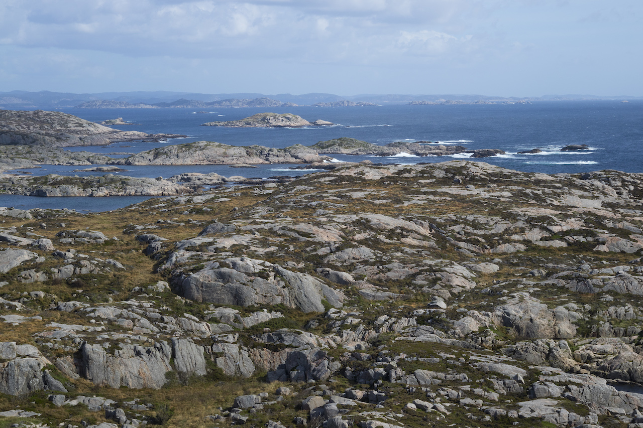
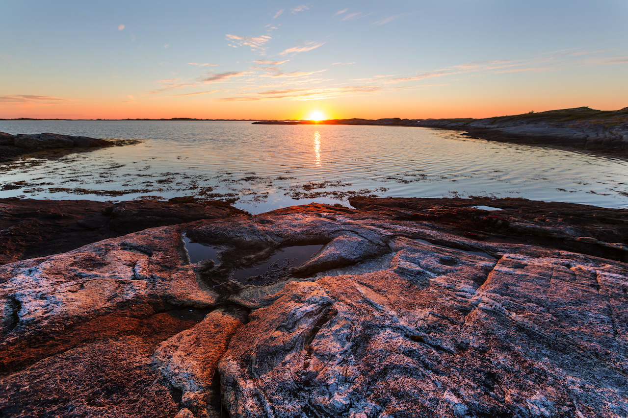
Verdens Ende, “The World’s End,” is located outside Tønsberg in Færder National Park. Five points on the planet are considered the “World’s Ends.” This is one of them, and from here, you get majestic views to the horizon. It's worth the detour if you have time.

Høydepunkter

Må vite

  • Å komme hit og bort: To get to Svinesund the nearest train station is Halden (Oslo – Gothenburg line) and from there, it’s a short ride to the Swedish Border. Lindesnes is a bit difficult to reach. The nearest train station is 60km away at Marnardal (Oslo – Stavanger line) or Kristiansand, a 100km ride. Nevertheless, you could take a bus (bike goes for free) fra Kristiansand to the towns of Mandal or Lyngdal which are around 30km and 40km away. There may be closer stops ask the bus driver.
    • We should note most people will start this route in Oslo and follow the main cycle route to Moss where you cross the fjord. From there you will join back on the official route.
  • Når du bør dra dit: Late April to September is the prime time to ride this. You could possibly ride it in early April or October but expect cold conditions. You should also note that the two old ferries may only run in the summer months (road detours are possible). Each of the pretty coastal towns will have folk festivals and events during the summer months. Do some research; you might find one or two happening as you cycle by. Risør’s famous Wooden boat festival is very popular!
  • Mat og forsyninger: you shouldn’t need to carry more than 1/2 a day’s worth of food with you at any one time. Shops are plentiful but most will be closed on Sunday.
  • Vann: It should be very easy to find water along the route. Churches, gas stations, supermarkets, public toilets, etc, are easily found in the many population areas you pass.
  • Sykkeltype: Du kan bruke alle typer tursykler på denne ruten (landevei, grus, fjell), men sørg for at den har innebygd komfort, for det kan bli lange dager på veien. Med begrenset klatring bør du ikke være for opptatt av kassett/gearvalg.
  • Gas stations and small shops will be open on Sunday, especially in tourist towns.
  • Sjekk rutetider for fergene: some run infrequently (transport tab).
  • Offentlige toaletter: Finding public toilets should be relatively easy with so many towns and villages to pass through.

Overnatting

  • Villcamping: This will be one of the hardest places to find suitable camping spots. Around Oslo fjord, it is very difficult and along the south coast, there is limited uncultivated land. It can take a long time to find somewhere and I think using the many campsites along the coast is a better option for this section of Norway
  • Campingplasser og hytter: There are enough campsites scattered along this route and thus you shouldn’t have many problems finding one. Most camping cabins may be booked up for weeks in advance during summer. It might be best to phone and check available tent spaces before turning up at some of the popular sites. Note, Oslo Fjord has a limited amount of campsites – best to do your research before setting off. Use Norcamp app.
  • Hoteller og vandrerhjem: You will find ample accommodation options from budget to very exclusive boutiques and spas. It is very easy to do this route with only roof-only accommodation. MenI juli kan det fort bli fullt på hotellene. Hvis du prøver å finne overnatting i siste liten, er det kanskje bare de dyreste hotellene som er igjen. Jeg vil anbefale å bestille minst en uke i forveien hvis du vil ha garantert hotell til en rimelig pris.
  • Airbnb: There are many options along the route and I found some really good ones (budget friendly) in rural areas away from the tourist towns.

Video

Transport

The 4 Ferries on the route:

The first two ferries are free to cyclists.

For the last two, a small price is charged for each (60-100kr) – These are very charming old boats.

If any of the ferries are not operating it’s easy to detour around and join back on the main route.

Andre alternativer:

  • Local Ferries: There are no express ferries connecting the towns. There are some small local ferries taking you to some of the famous islands mentioned in the highlights tab.
  • Tog: The main train line Oslo – Stavanger runs through sections of this route. Along Oslo Fjord, to Larvik and Porsgrunn you will find stations not too far away. Unfortunately, after that, the line heads inland and away from the coast. None of the coastal towns with the exception of Kristiansand (Arendal with connection) has a train station. You will need to detour 30+km away from the route to reach a station.
  • Busser: Det går lokale busser mellom byer og landsbyer. Du kan planlegge og bestille ved hjelp av lokale transportapper. Sykler er vanligvis tillatt.
  • Long-distance Buses: These don’t allow bikes on board!

Sikkerhet

Tunneler

There are just 4 tunnels on the route and none of them are of any concern. Three have gravel tracks around them and the one you go through is just 212m on a quiet road.


Travle veier

None: I can’t recall any busy or dangerous roads to worry about on this route. This is a highly populated area and thus there are many minor roads which get little traffic. On the east side of Oslo Fjord are a few poorly maintain gravel sections through farmland and forest. They are fine to cycle but not in good condition.


Været

As already mentioned, this is the driest and warmest part of Norway. The sea temperatures can be pleasant during summer and air temperatures can be well above 25 Celsius. Like anywhere in Norway rain can occur but you should find summer average temperatures comfortable. Always carry some warm clothing but hopefully, one or two layers are enough during the daytime in the summer. The wind however can be strong on the coast. West to East will on average have more tailwinds.

Videre lesning

Liste over klær

Offentlig transport

Utstyrsliste

Åpning og stenging av veier

Overnatting

Finnmark har også en viss mystikk. Med omtrent samme avstand fra Oslo som Istanbul, er det på sett og vis siste stopp før Nordpolen. Reisens utvilsomme høydepunkt er rett og slett å sykle gjennom Europas siste store villmark. Det vil føles veldig ensomt her oppe, men er ikke det en grunn til å sykle? Sykkelvarmekartene over verden er fulle av velbrukte veier. Her blir du med en liten gruppe syklister på jakt etter noe ekstraordinært. Du passerer villreinflokker og ser kanskje ikke et annet menneske på mange timer - det var vel derfor du kom? Turen avsluttes i byen Kirkenes, som har russiske veiskilt. Dette indikerer at du har nådd grensen til den vestlige verden!

Transport

Finnmark har også en viss mystikk. Med omtrent samme avstand fra Oslo som Istanbul, er det på sett og vis siste stopp før Nordpolen. Reisens utvilsomme høydepunkt er rett og slett å sykle gjennom Europas siste store villmark. Det vil føles veldig ensomt her oppe, men er ikke det en grunn til å sykle? Sykkelvarmekartene over verden er fulle av velbrukte veier. Her blir du med en liten gruppe syklister på jakt etter noe ekstraordinært. Du passerer villreinflokker og ser kanskje ikke et annet menneske på mange timer - det var vel derfor du kom? Turen avsluttes i byen Kirkenes, som har russiske veiskilt. Dette indikerer at du har nådd grensen til den vestlige verden!

Vilkår for bruk

Husk på

Alle sykkelruter som publiseres på CYCLENORWAY.com er kun ment som en planleggingsressurs som du kan bruke som inspirasjon i forbindelse med dine egne undersøkelser. Alle ruteanvisninger er utarbeidet etter grundige undersøkelser. Vi kan imidlertid aldri garantere at rutene er helt nøyaktige. Sykling i Norge er generelt sett svært trygt. Likevel, hvis du velger å sykle denne ruten, gjør du det på egen risiko.


Sjekk værforholdene

Vi anbefaler at du sjekker værforholdene langs ruten og holder øye med stengte veier og landområder. 

Se denne nyttige videoen for å se hvordan rutene kan lastes opp på mobilenheten og sykkelcomputeren din.

Det er tøft å sykle langt, og du bør ikke prøve deg på ruter som er over ditt nivå. 

Følg alle regler og forskrifter når du camper i naturen. 

Hvis du oppdager unøyaktigheter på denne siden, vennligst gi oss beskjed slik at vi kan rette dem opp.

Flere ruter i området

Hallingdal & Rallarvegen

Dette er et sykkelpakkeparadis der natur, grus og vei kombineres for å gi deg en opplevelse som ikke ligner noe annet.

Hallingdal & Rallarvegen

Dette er et sykkelpakkeparadis der natur, grus og vei kombineres for å gi deg en opplevelse som ikke ligner noe annet.
Telemark-sykling

Telemarkskanalens rute

Telemark er et unikt område i Norge og en skjult perle på sykkelradaren. Ta med telt og utforsk underverkene i dette enorme skog- og fjellterrenget. Det er det Norge du ikke visste eksisterte.
Telemark-sykling

Telemarkskanalens rute

Telemark er et unikt område i Norge og en skjult perle på sykkelradaren. Ta med telt og utforsk underverkene i dette enorme skog- og fjellterrenget. Det er det Norge du ikke visste eksisterte.

Lindesnes - Bergen

Tre byer og massevis av eventyr innimellom. Det er her det varme sør møter det uforutsigbare vest. Fjorder, strender og "djevelens tenner" står på menyen i denne kontrastfylte regionen.

Lindesnes - Bergen

Tre byer og massevis av eventyr innimellom. Det er her det varme sør møter det uforutsigbare vest. Fjorder, strender og "djevelens tenner" står på menyen i denne kontrastfylte regionen.

Legg igjen dine tanker nedenfor

Hold deg oppdatert med det siste fra den norske sykkelscenen.

Abonner på vårt månedlige nyhetsbrev

ikke-påtrengende, og tilbyr informative nyheter, blogginnlegg, videoer og mer.